Coronavirus/COVID-19

Public Health References
CDC * Colorado * Jefferson County * City of Golden
JCPHD updates these numbers Monday through Friday at about 3 PM. Here’s the most recent Coronavirus report from Jeffco Public Health’s Case Summary Page:
Cases in Jeffco – Thurs: 10,472 | Fri: 11,143 (+671)
Deaths in Jeffco – Thurs: 338 | Fri: 346 (+8)
Ever Hospitalized in Jeffco – Thurs: 794 | Fri: 834 (currently 114) (+40)
Recovered – Thurs: 7,810 | Fri: 8,275 (+465)
Known Cases in Golden – Thurs: 339 | Fri: 358 (+19)
Note: Based on the rate at which Jefferson County cases have been climbing, next Monday (November 9th) our status will change from “Level Yellow: Safer at Home Concern” to “Level Orange: Safer at Home High Risk.” See Public Health Order 20-36 for the definitions for those levels.
School of Mines COVID-19 case page. | Masks are required. | City and County fire restrictions are in place. | Sign up for exposure notifications.
Virtual Golden

9AM-2PM Brunch at the Rose
10AM Zoom into Water Color with Janet Nunn – November Notecards
10AM Virtual Coffee with Councilors
Golden Civic Foundation’s Gala Night in Golden
Real World Golden
Golden History Moment
You’re no doubt familiar with 8th, 9th, and 10th Streets. 8th Street has lots of townhomes and apartments on it. 10th Street takes you to City Hall, the History Museum, the Library, the rec center, and Lyons Park. 9th Street is the one between them, with charming historic homes.
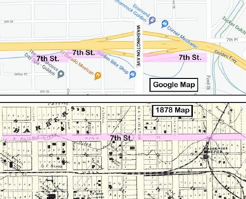
How often have you been on 7th Street? Never? That’s not surprising–there’s very little to it. That wasn’t always the case. Originally called “King Street,” 7th used to extend from Maple to East Streets–7 blocks.

Highwy 58 (the “Golden Freeway”) was planned in the mid-1950’s. In 1964, the State Highway Department began acquiring the homes that stood in the way of the new highway. A total of 23 homes and two brick apartment buildings were either demolished or moved. As a result, 7th Street now consists of two one-block segments and one two-block segment.
Many thanks to the Golden History Museum for providing the online cache of historic Transcripts, and to the Golden Transcript for documenting our history since 1866!

